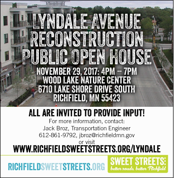
Lyndale Avenue Frequently Asked Questions
PEDESTRIAN AND BICYCLE SAFETY IS OUR BIGGEST CONCERN. THE 70TH STREET INTERSECTION INVOLVES A SCHOOL, ATHLETIC FIELD, NATURE CENTER, CHURCH AND MTC BUS STOP. WON’T THE PEAK TRAFFIC TIMES FOR PEDESTRIANS AND VEHICLES TOGETHER EXCEED THE SAFE CARRYING CAPACITY OF THE ROUNDABOUT?
A traffic analysis was completed as part of the preliminary design process. If the safe carrying capacity was exceeded, a roundabout would have not ever been considered at this location. During the design process we compared the multi-modal safety between a traffic signal and a compact roundabout at 70th and Lyndale – it was determined that a roundabout at this location is safer, resulting in the Transportation Commission’s recommendation to have a roundabout at this location.
- Conflict (or decision) points are a significant factor in understanding safety—roundabouts greatly reduce conflict points for vehicles and pedestrians. The conflict points that do remain in and near the proposed roundabouts are much safer for all users as the vehicle speeds are greatly reduced.
- Analysis of pedestrian safety at intersections also considers the distance of the crosswalk to the nearest curb. In the proposed roundabout design pedestrians will enjoy a median refuge and need only cross 20’ of one-way traffic at a time.
- The roundabout decreases speeds, reduces conflict points, and has shorter crosswalks when compared to traffic signals. These comparisons hold true for all the proposed Lyndale roundabouts.
WHY SO MANY ROUNDABOUTS ON LYNDALE?
We’ve heard this question many times. Roundabouts are a proven safer alternative to traffic signals for vehicles, pedestrians and bicyclists. Our community-based design process evaluates and considers the benefits of various traffic control tools for a given intersection. On Lyndale, the benefits of signals, roundabouts and stop sign control were compared to the project goals and project impacts
Specifically on Lyndale, in addition to being safer, using 3 single lane compact roundabouts at 67th, 68th, and 70th minimizes impacts to private property as well as to the Wood Lake Nature Center. The corridor design was modified to include a narrow median to restrict left turns into adjacent properties, compelling drivers to make a U-turn at the next roundabout and eliminating left turns across oncoming traffic—a dangerous conflict point in the current design. This reduced property impacts to those impacted by the access change.
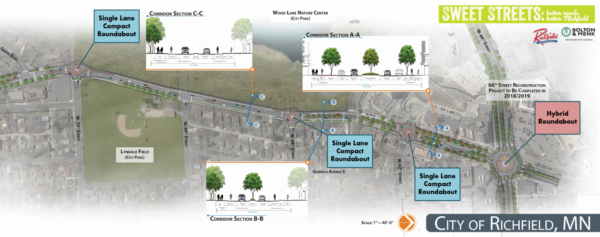
A key takeaway from our public involvement process—which included 4 open houses, 8 Transportation Commission meetings and multiple City Council work sessions—was the excessive vehicle speeds along Lyndale. The roundabouts will provide a calming atmosphere in this area while slowing cars down significantly and improving the pedestrian and bicyclist experience, a key goal identified during the public involvement process. In addition to speed reduction, roundabouts increase driver awareness and have less conflict points—a reduction in conflict points improves safety by reducing crashes and crash severity.
Along the redesigned Lyndale Avenue the 3 single lane compact roundabouts combined with the hybrid roundabout at 66th Street will work to improve safety, lower vehicle speeds, enhance the pedestrian and bicyclist experience and decrease traffic delays.
WON’T RESIDENTS LIVING ON LYNDALE AVENUE, OAK GROVE BOULEVARD AND 71ST STREET STRUGGLE TO SAFELY ENTER LYNDALE AVENUE WITHOUT A SIGNAL LIGHT TO DISRUPT THE FLOW OF TRAFFIC?
From our experience with the Portland roundabout we have no evidence that residents will struggle to enter Lyndale from their properties, from Oak Grove, or from 71st. The roundabout as designed at this location during peak travel times will experience a traffic load of roughly 65% of its carrying capacity using current and future traffic patterns which simply indicates there will be ample opportunity for entrance onto Lyndale. This analysis led us to conclude that there will be sufficient gaps to enter Lyndale occurring on average every 20 seconds at the busiest periods. These gaps are created by the very nature of a roundabout. For instance, cars turning from 70th onto southbound Lyndale will interrupt the flow of southbound Lyndale traffic. Similarly, as a southbound vehicle uses the roundabout to turn eastbound on 70th, you will have another gap in traffic south of the roundabout on Lyndale.
Complaints and issues related to property access and road access near roundabouts with similar situations have simply not manifested themselves in our experience. We see absolutely no reason why the Lyndale and 70th area will be any different.
WOULDN’T A SIGNAL AT 70TH SAVE THE PROJECT MONEY OVER A ROUNDABOUT?
No, a roundabout is more cost effective than a signal at his location. A signal at 70th Street would add more impacts to Wood Lake Nature Center on the north leg, caused by the need to provide a left turn lane at 70th Street. Providing the left turn lane required for a signal increases the length and size of the retaining wall along Wood Lake Nature Center. Installing a signal at 70th instead of a roundabout would add an estimated $320,000 to the cost of the project.
WHY DO WE NEED MORE BIKE LANES ON LYNDALE AVENUE?
Richfield has a Council approved Bicycle Master Plan for the City to guide infrastructure planning and design. The plan identifies routes to important destinations such as schools, parks, neighborhood commercial districts along with connections into adjacent communities. These routes do not designate the type of facility, but the plan does recognize that the skill levels of bicyclists range from beginner youth through commuter with recreational riders in between. Each of these groups may require different facilities when a project is designed.
Lyndale Avenue has all types of land uses and cyclist skill levels to consider in its design. The younger and recreational riders can use the path or sidewalk which is separated from traffic with the boulevards. Higher skilled riders can use the on-street bicycle lanes or the path.
The 3-lane roadway design standards require a 4’ shoulder and the on-street bicycle lanes on Lyndale will be 5 feet wide. This results in the need for only minor widening of the shoulder in order to accommodate the higher skilled riders along Lyndale as those individuals commute or access the numerous local destinations along the roadway.
WHY IS THERE A 17 FOOT WIDE EXPANSION ON THE WEST AND 6 FOOT EXPANSION ON THE EAST SIDE OF LYNDALE AVENUE?
The approved Lyndale corridor layout was designed using a community-based input process with consideration of the multi-modal vision set forth in the City of Richfield’s Guiding Principles, adopted in early 2013. The design utilizes existing City right-of-way that was set aside for the purpose of future infrastructure like this in the early 1920’s. From the centerline of the current Lyndale configuration, this right-of-way extends 33’ to the east and 50’ to the west. The design falls mostly within this city-owned right-of-way and the incorporation of tree-lined boulevards, dedicated bike lanes, sidewalks, a multi-use path, and left-turn lanes works to achieve many of the project goals. The project goals were developed through the public involvement process and are shaped by the City of Richfield’s Guiding Principles.
Lyndale will also be converted from a 4-lane undivided roadway to a 3-lane roadway. Portland, Nicollet, and Penn Avenues have all been similarly converted within Richfield and also have similar traffic volumes. Our experience with these roadways does indicate that it can be more difficult to cross or turn left onto these roads during peak traffic periods, but we have not experienced significant complaints or concerns from nearby residents and businesses to date. This is a trade-off of converting from a 4-lane road to a 3-lane road but it brings with it the safety benefits of left turn lanes and multi-modal facilities.
WHAT IS THE DIFFERENCE BETWEEN PRIVATE ENCROACHMENTS VS DIRECT PRIVATE PROPERTY IMPACTS?
Private Encroachments are fences, plantings, irrigation systems, retaining walls and other private features placed within the City’s right-of-way. In order for a resident/business to place private encroachments within the City’s right-of-way, a boulevard feature permit must be applied for. The boulevard feature permit states:
“I hereby acknowledge that this information is correct and that I agree to conform
to City of Richfield ordinances and State law regarding this installation and further
agree to pay the permit fee of $ 30, and, if at anytime the City of Richfield shall
make any improvements in any part of the right-of-way which affects the feature,
then the owner of the feature agrees to alter, change, move, vacate or remove said
feature to conform with such City improvements at the sole cost of the owner.”
Direct Private Property Impacts are impacts to private property. The direct private property impacts on the Lyndale Avenue Project occur at some of the new corners of the roundabouts. A sidewalk easement is needed at these locations. The property owners who are affected by private property impacts were contacted before City Council approval of the new Lyndale Avenue layout. There are no other direct private property impacts associated with the approved layout.
To find out where your private property line ends and the City right-of-way begins, please visit the Hennepin County GIS website- Find my property. (after searching your address, click on the map layers to turn on the imagery view).
WHY THE LOSS OF SO MANY MATURE TREES (INCLUDING 100+ YEAR OLD OAK TREES)?
Through the final design process staff worked to preserve as many mature trees as possible. Unfortunately, the complete replacement of the community’s underground utility infrastructure along the corridor required the removal of some mature trees. Tree preservation is a priority for us as we move any project forward, and we’re happy to report success as we worked with individual homeowners on options for saving specific trees in the right-of-way. To-date we have met with approximately 30 residents/businesses along the corridor, discussing and evaluating the design. Those meetings went well and the project team has been able to save 19 out of 25 oak trees between 70th and 74th. Of the 6 that were still identified for removal, 3 were unhealthy and would be taken down regardless of the project.